Best trips in Bohinj
What to do in Bohinj attractions
THE BEST DAY TRIPS IN BOHINJ WITH TOP SIGHTS AND TOURS AROUND LAKE BOHINJ AND TRIGLAV NATIONAL PARK
The best trips in Bohinj
The best trips in Bohinj or any trips in Triglav National Park are always the ones that bring up the best memories: having great time outdoors with memorable experience and renewed energy. Julian Alps in Triglav National Park with intact, pristine nature and amazing natural sights will make you fall in love with Bohinj and leave you craving for more. Bohinj Attractions are amongst the most beautiful in the area!
We have prepared this Bohinj What to do & Bohinj Attractions visual guide for your convenience. Starting from the doorstep of Sunrose 7 in Bohinjska Bistrica, the Julian Alps and Triglav National Park will lure you to explore and discover Bohinj attractions and surroundings. Trips in Bohinj are sorted for trip duration from our hotel and back in increasing order.
Bohinj what to do

BISTRICA RIVER SPRING
Walking to the Bistrica River spring will take you on a refreshing journey through forests all the way to the cascading springs.
Bistrica river spring from hotel and back: 2 h

SAVICA WATERFALL
Waterfall Savica is the most popular natural sight in Bohinj. A spectacular waterfall of immense beauty.
Savica from hotel and back: 2-3 h

VOGAR VISTA & KOSI VIEWPOINT
Vogar is a popular trip in Bohinj with splendid views of the Lake Bohinj and a lovely paragliding launch spot.
Vogar from hotel and back: 3-5 h

KORITA MOSTNICE WALKING
Amazing round trip walking around Korita Mostnice in Triglav National Park is one of the best Bohinj sights in all seasons.
Korita Mostnica from hotel and back: 2-4 h

ALPINE FORTIFICATIONS RIDGE
Panoramic and historical ridge is easy to hike with amazing views and lots of war heritage sights along the way.
The ridge from hotel and back: (Soriška planina start.): 3-5 h

VOGEL MOUNTAIN
Trip to Vogel with the cable car is easy and enjoyable way to the alpine fresh air and amazing hiking with views of the Julian Alps.
Vogel from hotel and back: 2-6 h
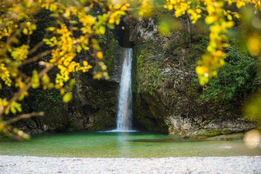
GRMEČICA WATERFALL
Slightly neglected, but a beautiful waterfall in the embrace of nature. A popular one also runs through the Grmečica canyon kanjoning.
Grmečica from hotel and back: 2-3 h

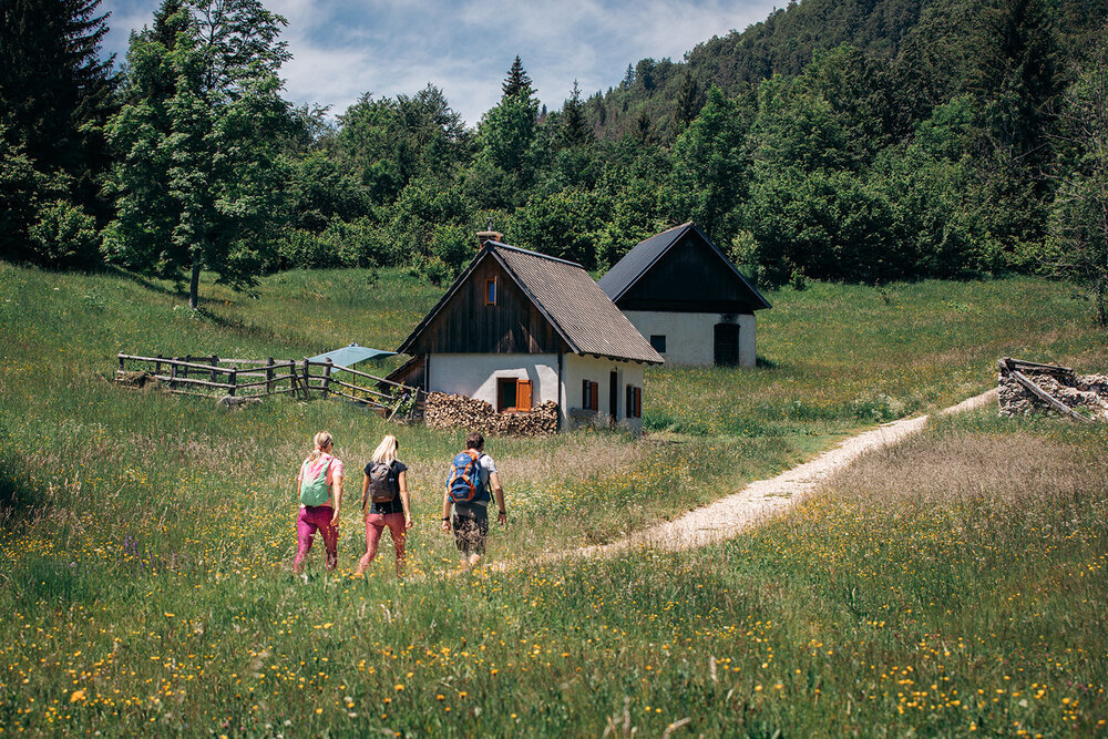
ROUND TRIP TO THE LAKE AND BACK
A hidden gem circular path to the Lake Bohinj and back, following the famous Juliana Trail stage 7.
Round trip from hotel and back: 3-5 h

A WALK AROUND THE LAKE
Lake Bohinj is a must see for every visitor and walking and circumnavigating the Lake is an amazing experience.
Walk around the Lake and back to the hotel: 4-8 h
Bistrica River Spring
BISTRICA RIVER SPRING TRIP DESCRIPTION
Turn left leaving our hotel door to the main road (50 m). Turn left again and after about 150 metrih (before the bridge) turn right uphill where suddenly paved road ends. Continue on a path past Rebro, where a historical - memorial graveyard from 1st WW is. Follow the path until you reach a country gravel road, turning right to the Bistrica river spring (marked path).
Walking time to the spring: 1 h

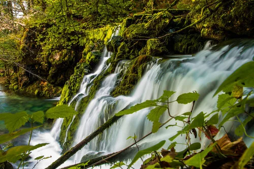


Mostnica Gorge - top Bohinj Attractions
Mostnica Gorge is one of the most beautiful sights in Bohinj and Triglav National Park that is somewhat overlooked. Mountain river Mostnica carved amazing forms in the limestone. This popular trip can be extended all the way through Voje valley to the waterfall at the end. Korita Mostnice gets our vote as the first among all must see natural sights of Bohinj.
KORITA GORGE TRIP DESCRIPTION
Click here for a full trip report with photos of Mostnica Gorge.
Duration: 1-3 h for a round trip (counter clockwise) of the Mostnica Gorge alone.


Waterfall Grmečica
Grmečica waterfall is the last and tallest waterfall of the Grmečica mountain stream. It is about 7 meters high and falls into a beautiful alpine pool. Grmečica waterfall is located near the right bank of the Sava Bohinjka, between the settlements of Log in Bohinj and Nomenj. The Grmečica creek springs about a kilometre above the 100 m long gorge of the Grmečica. From the waterfall, Grmečica flows through forest and pastures into the Sava River at Nomenj.
WATERFALL GRMEČICA TRIP DESCRIPTION
Turn right leaving hotel Sunrose 7 doorstep, turn right again over the bridge of the river Belca and immediately left toward the railway station Bohinjska Bistrica (250 m). From the railway station, walk along Ajdovska cesta and before the second bridge over the Belca stream, turn right down the slope and then after a few meters to the left again, following the asphalt road, which turns into gravel road after just a 100 meters. Overlooking Ajdovski gradec hill (580 m), we continue under the railway bridge (which leads across the Sava Bohinjka River) to the end of the gravel road, where a house stands (this whole gravel road is actually a part of Ajdovska cesta, which is the longest street in Bohinjska Bistrica). In front of the house, the signs direct us towards the Grmečica waterfall. We continue across the meadow and when we are opposite the village of Lepence we cross a torrent. From there, the path winds right along the Sava for some time. There is one slightly more difficult part, where we can use a help of a in-situ rope for about 2 m steeper hike. From here we soon reach wide cart track, which takes us from the forest to the meadow and to the village of Log. We continue to the end and turn left onto another tractor track which crosses a large meadow. The pleasant path which continues through the forest, then continues along the Sava Bohinjka River and then winds slightly to the right. It is only a few minutes walk now and the path will take us to the Grmečica waterfall.
A visit of Waterfall Grmečica is highly recommended, especially in spring or after a period of heavy rain, when there is lots of water. Please bear in mind that there is cattle and pastures that are private property along the way, so please be respectful.
Duration: 1 hour


Savica Waterfall Bohinj
The Savica waterfall is a mighty waterfall that falls over a slope in the Komarča wall and is no.1 on Bohinj attractions list. The Savica waterfall is the source of the Sava Bohinjka river, which is called the Savica river until it empties into Lake Bohinj. The Savica waterfall is one of the most visited sights in Slovenia, and certainly Bohinj. The Savica waterfall is a unique feature among waterfalls in the world, as the water flow is already divided into two strands in the hidden underground. The famous A-shaped waterfall at normal water level comes to the surface at an altitude of 836 m and is 78 m high. It is fed by water, which flows from the Valley of the Triglav Lakes and below Pršivec and flows to the waterfall through a horizontal cave tunnel. The original karst cave hides many siphons and underground lakes in its depths.
ROUTE DESCRIPTION FOR SAVICA WATERFALL
If the starting point is in Ukanc, a beautiful marked path will take you to the parking lot below the Savica Waterfall in less than an hour. If you arrive by car or bus, you park in the parking lot below the Savica Waterfall. The path to the waterfall leads along a well-kept path and numerous stairs. To see the waterfall, a fee is paid at the beginning of the trail.
Time: about 25 minutes from the parking lot to the Waterfall
The Rapallo border
The Rapallo border was created after the signing of the contract with Rapallo. It was part of the infamous Italian fortification system, which ran along the t.i. Alpine wall (vallo alpino). Above Soriška planina, the system of military fortifications, bunkers and other remains is easily accessible and perfectly preserved.
ROUTE DESCRIPTION FOR LAJNAR, DRAVH, MOŽIC
From Soriška planina, which can be reached on foot, by bike, bus or own car, turn towards the ski center Soriška planina and continue along the marked path to the ridge. There are several paths, the easiest way is to follow the signs for Lajnar. When you reach the ridge along the ridge there is a scenic path that once connected bunkers and other military facilities along the Alpine wall. The bunkers are perfectly preserved, which is why they invite you to explore. To the south there is a view of Sorica, and to the SW there is a beautiful Baška grapa. The trip can end with Lajnar, but you can extend it along a light, comfortable mule track with exceptional views and visit the barracks under Kora, as well as Slatnik, Dravh and Možic. From the latter you can see both Lake Bohinj and Lake Bled, and below it is also a large underground fortress and a system of bunkers.
Time: From Soriška planina 30 minutes to the ridge, and the continuation depends on the choice of destinations. The whole round about 3 hours.


PANORAMIC RIDES on SORIŠKA PLANINA PEAKS
Spectacular views of Mt. Triglav and all the way to the Adriatic sea from top Lajnar, which can be accessed with chairlift Lajnar.
ALPINE FORTIFICATIONS RIDGE - THE RAPALLO BORDER TRAIL
Panoramic and historical ridge is easy to hike with amazing views and lots of war heritage sights along the way. Guided tours are available as well.
The ridge from hotel and back: (Soriška planina start.): 3-5 h
Follow the circular path to Lake Bohinj and back
DESCRIPTION OF THE ROUTE TO LAKE BOHINJ AND BACK TO THE ROUTE OF THE 7TH STAGE OF THE JULIANA TRAIL
From the threshold of our hotel Sunrose 7, turn left and follow the main road through the roundabout straight in the direction of Lake Bohinj. When you cross the bridge over Bistrica, turn left and follow the main road to the exit, where the macadam (and signs) begin. Follow the signs for Ribčev Laz or. Stara Fužina to the lake and enjoy the beautiful views. You can return from Lake Bohinj to the Sunrose 7 Hotel via a dual-purpose route (also the Stara Fužina - Bohinjska Bistrica cycle path). When you arrive in Bohinjska Bistrica at the Danica camp, cross the wooden bridge and join the already walked path.
Time to the lake about 1h 30 min and the same back.
We recommend refreshing in the lake and enriching the trip with a short walk to the beautiful Peč lookout. You ascend to Peč from Stara Fužina, the path is marked, follow the signs for the ascent to Rudnica.
Excursion to Vogar - Kosijev razglednik and Kosijev dom na Vogarju
DESCRIPTION OF THE ROUTE TO VOGAR. DESCRIPTION OF THE ROUTE TO THE KOSI VIEWBOOK.
Vogar is a popular excursion point with beautiful views of the lake and the Bohinj-Tolmin mountains. Vogar is also the easternmost peak of the ridge north of Lake Bohinj and a popular take-off point for paragliders.
To Kosi's lookout, which is a bit less popular, but perhaps even more beautiful, the path leads past Kosi's home to the west. A well-trodden path takes you to a lookout point with a bench and a view of the western shore of the lake and Ukanc in less than 10 minutes from home. The starting point for Vogar is in the village of Stara Fužina, from where we follow a comfortable but steep marked path. The starting point can be reached by car, in the summer months also by free bus or bicycle. An alternative starting point is at the top of the road for the Vogar and Blato alpine pastures (10 km of road, fee to be paid). From the parking lot on Vogar to the lookout is about 20 minutes walk. Time: Ascent: 1h 20min, descent 1h.
Please check Soriška planina offer of Guided tours and chairlift rides for details.


Vogel
Vogel is a wonderful winter center, which, especially in recent years, is increasingly attracting visitors even in summer. Of course not, when the cable car provides a convenient approach to a very scenic spot above Lake Bohinj. The upper station of the cable car is an excellent starting point for many mountain excursions, among which we especially recommend:
A relative
Dry Mountain
The top of the neck
The walking time depends on the chosen destination. Guests can park for free at the lower cable car station. We recommend suitable hiking shoes and other equipment.
Excursion around Lake Bohinj
DESCRIPTION OF THE ROUTE AROUND BOHINJ LAKE
We recommend a trip around Lake Bohinj in the morning, when nature serves with beautiful light and you can observe the play of colors and shadows on the lake surface. The path around the lake is well-trodden and comfortable and marked with markings and boards. The start is in Ribčev laz, where you continue along the north coast and return along the south coast. Extensive record of a walk around Lake Bohinj. Walking time: 2-5 hours for the entire circular route. We recommend that you cross the north side of the lake and take a boat back from Ukanc to Ribčev laz.


Črna prst across the mountain behind Lisce
Črna Prst is an important peak in the ridge of the Lower Bohinj Mountains. On its southern slope is one of the oldest alpine botanical peaks, where our Sunrose flower, after which our hotel got its name, thrives. On the northern slope of the peak head of the Black Earth, we notice the black earth (earth) after which the mountain got its name. Only a few meters below the top is the mountain lodge Zorka Jelinčič, which is open in the summer season.
ROUTE DESCRIPTION - ČRNA PRST FROM BOHINJSKA BISTRICA
From the threshold of our hotel turn left and to the main road (50 m). Turn left again and after 150 meters (in front of the bridge) turn right uphill onto a sandy road. Continue along the well-trodden path past Rib, where there is a lookout memorial cemetery from the 1st c. wars. The marked path goes around the cemetery on the right, and then leads us across a spacious meadow, where a few minutes later we join a slightly wider cart track.
We continue slightly to the left, then a few 10 meters further we cross a macadam road, where at first a pronounced cart track gradually begins to climb. Higher, at the fork in the cart track, we choose the right branch, next to which are the old markings for Črna prst, and from there we go a little higher, once again slightly to the right, on the footpath, which begins to climb steeper. We climb all the time along rather sparse signs, and then on a small mowed meadow we reach a cart track, which we follow to the left, after which we reach a wider macadam road in a few steps.
When you reach the road, continue left down after the signs of Črna prst (right the old path towards Orožna koča), and lower at the marked crossroads turn right in the direction of Črna prsta, the mountain for Montenegro and Orožnova koča. The way forward on the right side goes around the house (sometimes the Mountain Lodge of Dr. Janez Mencinger), and then soon joins the cart track, along which we continue the ascent. Later at the crossroads we continue to the right, and then the path continues through the forest. A little further on, the path leads us past a log cabin and a cross, and then we arrive at a marked crossroads, where we continue right in the direction of Orožnova koča (left mountain for Montenegro). The path crosses the slopes slightly to the right and descends more visibly. When the descent is over, the old path joins us from the right, which is a bit shorter, but no longer officially marked. Followed by a walk along a forest path, where we cross a few cart tracks, and at the marked crossroads we continue on the right path. A few minutes higher we reach a forest road, which we just cross (on the right Orožnova koča by slide).
A relatively steep ascent through the forest follows, and a slightly longer path along the slide joins us from the right. Continue to the left and in a few minutes you will reach Orožnova koča on the mountain behind Lisce.
From the hut we continue in the direction of Črna prsta, along the path that goes into the forest and which initially runs along the botanical path. After the initial ascent, the path is laid quickly, then climbs transversely to the right, and occasionally also descends slightly. The higher botanical path turns right, and we continue along the marked path, which gradually becomes steeper, and in the meantime it also passes out of the forest. This is followed by an ascent along the slopes of Črna prsta, where the path temporarily becomes more rocky and for a short time also quite steep. The slope drops sharply, and the path turns left, where it ascends transversely over a short rather steep slope, then the path and slope are laid, and we only a little further arrive at a marked crossroads, where the path from the mountain to Montenegro and the path with Soriške planine.
We continue to the right and in a few steps ascend to the saddle Čez Suho, from where we have a beautiful view to the south. Here we continue to the right in the direction of Črna prsta and ascend along and along the viewing ridge. The path is quickly laid and passes on sunny slopes, where we can easily climb fairly steep grassy slopes. A little further on, the path turns slightly to the right and ascends to the Zorko Jelinčič Home on Črna prsta.
On the left side we walk past the lodge and step on the top of Črna prsta from which there is a beautiful view of the Gorenjska and Primorska side.
Time:
Bohinjska Bistrica - Orožnova koča 2:20
Orožnova koča - Čez Suho 1:05
Across Dry - Black soil 15 minutes